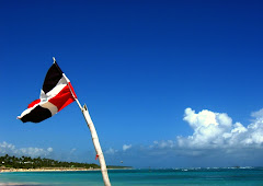
 The Dominican Republic is located in the middle of the Caribbean, what make her privilege of a wonderful geographic position.
The island was called "La Hispaniola" when christopher Colombus discovered, lately a border of 388 km separate the island in two different countries, The Dominican Republic in the East and Haiti at the west.
How you can see in the picture, the Island of Santo Domingo, how was called in time, is the second biggest island in the Antilles, is separate from Puerto Rico for the "Canal de la Mona" at the East, from Cuba at the west for the "Canal del Viento, up North have the Atlantic Ocean and the Caribbean sea in the South .
This wonderful Location allow the people to have a mix of the hot weather from the Caribbean Sea and a nice breeze coming from the Atlantic Coast.


No comments:
Post a Comment